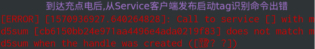
launch 和 lua 配置文件都是在install_isolated/share/cartographer_ros/launch/
和 install_isolated/share/cartographer_ros/configuration_files/
下,所以如果只修改了cartographer_ros软件包中的launch 和 lua 文件之后是需要重新编译的,编译之后才能将修改的文件安装到install_isolated文件中。
从cartographer启动时输出的信息可知,我们自己的lua加载的其他lua有:map_builder.lua
, pose_graph.lua
, trajectory_builder.lua
, trajectory_builder_2d.lua
. 它们的路径都在/usr/local/share/cartographer/configuration_files
。如果我们需要改这些基本lua的参数,可以在自己lua里覆盖地修改,直接改原文件不太好,它们的关系如下:
map_builder.lua
和trajectory_build.lua
起着总领的作用,前者包括的pose_graph.lua
为后端优化的具体参数配置; 后者是前端的参数配置,分为2d和3d两个文件。
lua_parameter_dictionary.cc
是用于lua参数的,如果这里有报错,基本是lua参数的语法问题
1 [/cartographer_node] [ScopedRosLogSink::send] line_63 F0402 21 :57 :53.000000 20519 lua_parameter_dictionary.cc:399 ] Check failed: HasKey(key) Key 'use_nav_sat' not in dictionary:
在lua文件里必须设置use_nav_sat
参数,同样报错的参数都要添加
自定义lua的参数 我用的是home.lua
, 先看options的内容,这是通用的参数。options块中定义的值定义了cartographer前端应当如何与机器人进行交互。 定义在options段后的值用于调试cartographer的内部信息
开头的map_builder = MAP_BUILDER
和trajectory_builder = TRAJECTORY_BUILDER
万年不变:1 2 3 4 5 6 7 8 9 10 11 12 13 14 15 16 17 18 19 20 21 22 23 24 25 26 27 28 29 30 31 32 33 map_builder = MAP_BUILDER, trajectory_builder = TRAJECTORY_BUILDER, map_frame = "map" , tracking_frame = "imu" , published_frame = "odom" , odom_frame = "odom" , provide_odom_frame = false , publish_frame_projected_to_2d = false , publish_tracked_pose = false use_odometry = true , use_nav_sat = false , use_landmarks = false , num_laser_scans = 1, num_multi_echo_laser_scans = 0, num_subdivisions_per_laser_scan = 1, num_point_clouds = 0, lookup_transform_timeout_sec = 0.2, submap_publish_period_sec = 0.3, pose_publish_period_sec = 5e-3, --频率可能比较高 trajectory_publish_period_sec = 30e-3, rangefinder_sampling_ratio = 1., odometry_sampling_ratio = 1., fixed_frame_pose_sampling_ratio = 1., imu_sampling_ratio = 1., landmarks_sampling_ratio = 1., collate_fixed_frame = true 是否将数据放入阻塞队列 collate_landmarks = false -- 一般都是false
坐标系组
有时遇到这样的报错:1 Check failed: sensor_to_tracking->translation().norm() < 1e-5 The IMU frame must be colocated with the tracking frame. Transforming linear acceleration into the tracking frame will otherwise be imprecise
这是因为在使用IMU的情况下,tracking frame
不是imu的link
published_frame: 位姿子坐标系的ROS坐标系,例如”odom”坐标系,如果一个odom坐标系由系统的不同部分提供,在这种情况下,map_frame中的odom
姿势将被发布。 否则,将其设置为base_link
可能是合适的
provide_odom_frame: true 适用于机器人本身没有odom坐标系的情况,如果启用,将发布局部、非闭环、持续的位姿,也就是odom_frame在map_frame中的坐标
odom_frame: 在provide_odom_frame为true才启用,坐标系在published_frame和map_frame之间用于发布局部SLAM结果,通常是”odom”
use_odometry: 如果启用,会订阅关于odom话题(或者叫其他名字)的nav_msgs/Odometry
消息。应当提供里程信息,这些信息包含在SLAM里
use_nav_sat: 是否使用gps数据。如果启用,将订阅sensor_msgs/NavSatFix
的话题,比如fix. 应当提供导航数据,将用于全局SLAM
use_landmarks: 如果启用,订阅cartographer_ros_msgs/LandmarkList
的话题,比如landmarks. 应当提供Landmarks信息,这些信息包含在SLAM里
use_pose_extrapolator
: 默认false. 发布tf时是使用 pose_extrapolator推断的位姿还是前端计算出来的位姿
1 2 3 4 stamped_transform.header.stamp = node_options_.use_pose_extrapolator ? ToRos (now) : ToRos (trajectory_data.local_slam_data->time);
旧版本没有这个参数,直接使用了now
。这个参数认为位姿估计器很精确,但前提是雷达频率高,时间间隔短。最好是使用前端的时间戳
publish_frame_projected_to_2d: 默认false. 发布TF变换时,是否将tracking在Local坐标系中的坐标投影到2D平面上,这只是个显示功能,不影响SLAM。
publish_tracked_pose: 是否发布话题tracked_pose
,也就是tracking坐标系在map坐标系的位姿,朝向与imu_link的x轴重合
num组 Cartographer
可以订阅的主题有三种,我们一般用scan
,还可以用echoes
或points2
,这三个是互斥的。分别对应lua中的num_laser_scans
, num_multi_echo_laser_scans
,num_point_clouds
. 这三个参数必须都是 >= 0 且三者之和 >=1 代码在ComputeRepeatedTopicNames
lua中将num_laser_scans
设置为1,则scan
将用作SLAM的输入,如果num_laser_scans
大于1,则多个编号的扫描主题(即scan_1,scan_2,scan_3,……直到并包括num_laser_scans)将用作SLAM的输入.
当num_point_clouds
为1时,默认订阅points2
话题的数据
同理,如果将num_multi_echo_laser_scans
设置为1,则echoes
做输入,但仅使用第一个回声,如果大于1,则多个编号的回声主题(即echoes_1,echoes_2,echoes_3,……直到并包括num_multi_echo_laser_scans)将用作SLAM的输入。echoes
的消息类型为sensor_msgs/MultiEchoLaserScan
,不同之处在于sensor_msgs/LaserEcho[] ranges
和sensor_msgs/LaserEcho[] intensities
首先需要雷达支持多echo,即每个脉冲发出以后,会有多个echo返回。我们知道一般雷达要避免扫描玻璃,因为laser会穿透过去,但多echo雷达不仅可以获得玻璃返回的echo,也能获得玻璃后面的墙返回的echo,这样我们就获得不同深度的信息,对建图定位的帮助更大。
points2
也是这样,消息类型sensor_msgs/PointCloud2
,num_point_clouds
适用于多线雷达,对于单线,设置为0
num_subdivisions_per_laser_scan: 将雷达一帧的数据拆分成几次发出来,必须>=1,默认10。在SensorBridge::HandleLaserScan
中调用, 对点云points细分。比如雷达scan有200束激光,本参数为10,那么转换成点云后,对点云取很多小段处理:(0,20)、(20,40)……(190,200)。 对于普通雷达来说,此处为1即可
period 组 都在Node
的构造函数里,是ROS定时器的发布间隔
lookup_transform_timeout_sec: 使用tf2查找tracking_frame
和雷达坐标系变换的超时秒数,在函数TfBridge::LookupToTracking
submap_publish_period_sec: 发布话题submap_list
的间隔
posepublish_period_sec: 对应`publish_local_trajectory_data_timer 和
Node::PublishLocalTrajectoryData`. 例如5e-3,对应tf发布频率为200Hz
trajectory_publish_period_sec: 发布轨迹节点和Landmark的时间间隔,对应PublishTrajectoryNodeList
和PublishLandmarkPosesList
ratio 组 5种观测的权重比
rangefinder_sampling_ratio: Fixed ratio sampling for range finders messages.
odometry_sampling_ratio: Fixed ratio sampling for odometry messages. 如odom的数据非常不准,可以设置为0.3,以减小odom对整体优化的影响
fixed_frame_sampling_ratio: Fixed ratio sampling for fixed frame messages.
imu_sampling_ratio: Fixed ratio sampling for IMU messages.
landmarks_sampling_ratio: Fixed ratio sampling for landmarks messages.
options结束后,一般有一句:MAP_BUILDER.use_trajectory_builder_2d = true
,这是因为map_builder.lua
中的这个参数设置为false了,我们在这里可以重新赋值,选择使用2D还是3D
不使用机器人的IMU和Odom 1 2 3 4 5 6 7 8 map_frame = "map" , tracking_frame = "base_footprint" , published_frame = "base_footprint" , odom_frame = "odom" , provide_odom_frame = true , publish_frame_projected_to_2d = false , use_odometry = false , TRAJECTORY_BUILDER_2D.use_imu_data = false --默认true
进行2d slam时,carto的默认配置是使用imu的,所以如果没有imu就要TRAJECTORY_BUILDER_2D.use_imu_data = false
,否则会一直等待imu的数据而进行不下去。而3D slam 必须使用imu,所以不必修改这个参数。
在2D中,Cartographer支持运行相关的扫描匹配器,用于局部SLAM中寻找循环关闭的约束条件。它的计算代价很大,但通常会使odometry或IMU数据的加入变得不必要。2D也有假设平坦世界的好处,也就是说,上升是隐式定义的。 在三维中,IMU主要用于测量重力。重力在测量中是一个很有用的量,因为它不漂移,而且是一个非常强的信号,而且通常包含了大部分所要测量的加速度。
Node::LaunchSubscribers
函数中有一段:1 2 3 4 if (node_options_.map_builder_options.use_trajectory_builder_3d () || (node_options_.map_builder_options.use_trajectory_builder_2d () && options.trajectory_builder_options.trajectory_builder_2d_options () .use_imu_data () ) )
显然源码里已经做了规定
如果我们不想使用轮式里程计, cartographer的lua无法屏蔽里程计,只能自己修改机器人的程序,不让它发布odom话题和odom--->base_footprint
的tf变换。如果不修改,使用时会发现tf变换一会儿由 cartographer发布,一会儿由机器人程序发布,千万不能由两个节点发布同一个tf变换, 从rviz看上去,RobotModel和LaserScan摇晃地很厉害。
这里有一个技巧, 观察一个tf变换是否由两个节点发布,用rosrun tf view_frame是看不出来的,应该用rosrun rqt_tf_tree rqt_tf_tree,然后用刷新按钮观察。
如果不用IMU,Odom + Lidar在局部存在纠偏失败的可能。 但是在里程计与imu不准的情况下,使用imu和odom反而建图效果会更差
使用机器人的odom和imu,lua做如下设置: 1 2 3 4 5 6 7 map_frame = "map" , tracking_frame = "imu" , published_frame = "odom" , odom_frame = "odom" , provide_odom_frame = false , publish_frame_projected_to_2d = false , use_odometry = true ,
一开始,我增加了参数TRAJECTORY_BUILDER_2D.num_accumulated_range_data = 10
,结果出现了scan一直在转的情况,使用tf_echo
map和laser坐标系的关系,发现y位移一直在增大,但x z基本不变。去掉这个参数后,不再一直转了,但是过了几分钟还是有所偏,地图还出现了重影,这说明是机器人的里程计误差问题,需要校准,这个参数应该是放大了这种现象。
如果不想每过一段时间就校准,那么odom
到base_link
的tf就用cartographer的,因为它有重定位,累计误差比较小,而且可以得到修正
对是否使用odom的两套程序如下:
查看节点cartographer_node
是否订阅了IMU和Odom,检查是否用到了它们
问题
使用IMU后,有时启动时会报警: 出问题的代码在cartographer::mapping::ImuTracker::AddImuLinearAccelerationObservation()
。启动一下imu程序,如果rostopic echo /xqserial_server/IMU/linear_acceleration
就会发现,imu线加速度开始为0,过了一秒左右才有数据,这应该是节点通信的问题。所以cartographer读取到的线加速度全是0,在程序里就会报错。此时再重启就没事了
建图时地图围绕原点转圈,画出来的是一团黑,可能是用到的IMU的加速度有问题,需要校准IMU。还有可能是ceres的平移和旋转的权重没有进行重新配置。
如果出现下面的输出,一般是scan
话题没有订阅到:
1 [ WARN][/cartographer_node] [ScopedRosLogSink::send] line_55 W0711 20 :05:58.000000 12245 ordered_multi_queue.cc:155 ] Queue waiting for data: (0 , scan)
正确的是这样:
1 [ INFO][/cartographer_node] [ScopedRosLogSink::send] line_51 I0711 20 :14 :56.000000 25541 ordered_multi_queue.cc:172 ] All sensor data for trajectory 0 is available starting at '637300664959145564' .
常常启动后出现这个报警: 这其实是tf坐标系的问题,cartographer源码里lookupTransform写的不好,不管也可以,详细分析可见
tf报警:Lookup would require extrapolation into the past
机器人在地图中的位置不稳定,有轻微摆动,tf_echo如下:
yaw有跳变, 判断是里程计累计误差
map_builder.lua 和 trajectory_builder.lua 内容只有几行:1 2 3 4 5 6 7 8 include "pose_graph.lua" MAP_BUILDER = { use_trajectory_builder_2d = false , use_trajectory_builder_3d = false , num_background_threads = 4, pose_graph = POSE_GRAPH, }
map_builder.lua内容太简单了,配置是使用trajectory_build_2d
还是trajectory_build_3d
,以及后端使用的线程数。 use_trajectory_builder_2d
在上面讲过改为true,其他一般不动,如果CPU性能好,可以增大num_background_threads
1 2 3 4 5 6 7 8 include "trajectory_builder_2d.lua" include "trajectory_builder_3d.lua" TRAJECTORY_BUILDER = { trajectory_builder_2d = TRAJECTORY_BUILDER_2D, trajectory_builder_3d = TRAJECTORY_BUILDER_3D, pure_localization = false , }
trajectory_builder.lua
更简单,只有一个pure_localization
区分是否使用carto用于机器人纯定位